

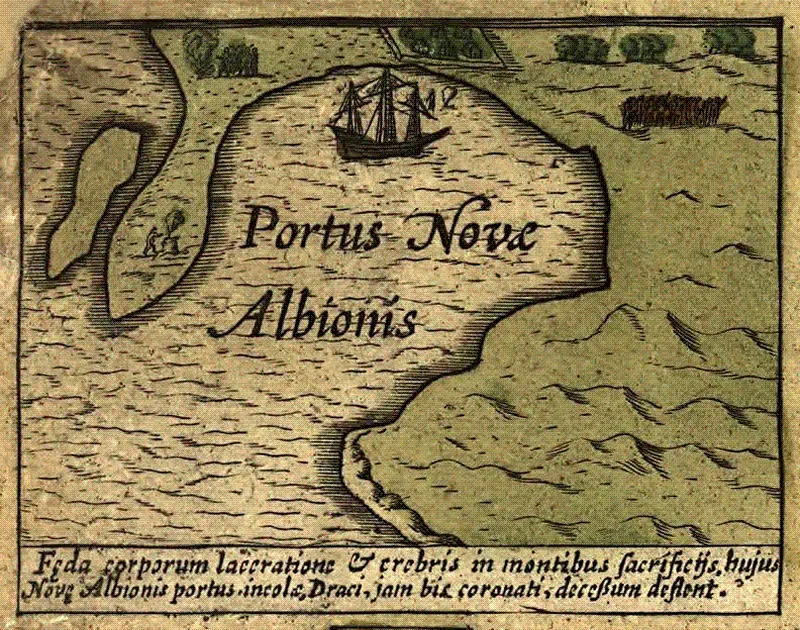
This page: marginal insert from the so-called “Drake Broadside Map,” by Jodocus Hondius, probably issued in Amsterdam, 1595. British Library. Front cover: photograph of the “plate of brass,” found near Drakes Bay in the 1930s and finally proved in 2003 to be the result of a hoax. Bancroft Library, University of California.
INTRODUCTION
In a previous essay I followed Christopher Columbus (1451-1506) as he found his way to the “New World” and back to Spain with incredible ease.[1] This time my subject comes from the exploits of another great navigator, Francis Drake (1540-1596). More aggressive than Columbus, he intruded deeply into the rich Spanish empire and beyond it, reaching the Pacific coast of North America in 1579, at least briefly, during a three-year voyage in the service of Queen Elizabeth I.
Drake eventually got home by sailing completely around the world, but circumnavigation was merely an afterthought–the glorious, unplanned deed that earned him a knighthood–not part of his original mission. He had been sent into the Pacific Ocean (by way of Magellan’s Strait) with three objectives: (1) to seize as much treasure as possible from Spanish galleons and seaports in South America and Central America; (2) to find an ice-free passage for shipping across North America, and (3) to claim territory near the Pacific end of that “Northwest Passage” for a permanent colony or military post.[2]
DRAKE’S FIRST OBJECTIVE
Drake was spectacularly successful in achieving the first of these three objectives. Working his way northward up the coast of what is now Chile, Peru, Panama, and so on, he seized so much of Spain’s ill-gotten gold, silver, and other treasure that by the time he crossed the Equator, heading towards North America, his small, heavily-laden ship simply couldn’t hold any more. To make it fit, he had already replaced the stone ballast of his vessel with some of the 26 tons of silver bars taken from one large Spanish galleon. That’s a lot of silver, and only a fraction of the total haul. But the haul was needed in London, not off the coast of Ecuador where Drake happened to be cruising at the moment. Queen Elizabeth lacked the resources to stave off a Spanish invasion of her kingdom, and Drake was only too well aware of this urgent need.
So he had a crucial decision to make: should he turn for home now, heading west across the vast Pacific with his precious cargo, or continue sailing northward for a while longer, in search of his second objective? If that legendary shortcut known as the “Northwest Passage” really existed, and if Drake could find its entrance without too much delay, then he might get back to England in a matter of weeks rather than months.
DRAKE’S DECISION
Drake, a superbly skillful sailor and often a lucky one to boot, decided to give it a try. Using charts and verbal directions taken from Spanish pilots he had captured, Drake followed the Pacific coast up to the port of Huatulco, Mexico (about 16° North of the Equator) where fresh water and other supplies could be obtained. From there he swung away in a northwesterly direction, sailing far out to sea, avoiding the prevailing winds along the coast because they blew strongly towards the south.
What happened during the next several months is not entirely clear. One Spanish account of his voyage suggests that Drake kept on going across the Pacific, heading home, without touching the coast of North America again.[3] Several English accounts tell us that he did swing back to this coast, many miles to the north, and he sighted land again, somewhere in the vicinity of what is now Portland, Oregon (45° North) or Seattle, Washington (48° North).[4] Drake’s own charts and records were evidently kept secret (against his wishes) upon his return to England, so the narratives we have are second-hand at best, and incomplete. If they are to be believed, Drake continued sailing northward up the coast a while longer, but we don’t know how far. Possibly to British Columbia, possibly to southern Alaska, before running into severely cold weather, giving up, and turning back.
THE FROZEN NORTH
How cold was it? Here is a paragraph from The World Encompassed,[5] a first-person narrative pieced together from several second-hand accounts by Drake’s nephew, and not published until 1628. “In this place was no abiding for vs, and to go further North, the extremity of the cold (which had now vtterly discouraged our men) would not permit vs; and the winds directly bent against vs, hauing once gotten vs vnder sayle again, commanded vs to the Southward whether we would or no.”
Regardless of how cold it was, regardless of how far north Drake may have gone, we can say with certainty that this outstanding navigator and sailor could not have achieved his next objective, because there was in fact no west-east waterway to be found in the latitudes he explored. Much farther north, centuries later, a way through the Arctic Ocean would finally be opened, and it is in use by sturdy ships today, but in Drake’s day, that passage was utterly impassable, the ice frozen solid, many feet thick.[6]
FAILURE TO FIND A NORTHWEST PASSAGE
Drake’s dilemma is easy enough for us to grasp, with the help of modern maps, satellite photos of the earth’s surface, first-hand knowledge of coastal geography, and possibly some hindsight; but for Drake and those who sailed with him, the push to find the Northwest Passage must have been extremely frustrating and confusing at times. Again our best source is The World Encompassed.[7] Having commented on the adverse conditions encountered in the north, particularly the cold weather, ice, thick mists, and “most stinking fogges,” the narrative continues: “we coniecture that, either there is no passage at all through these Northerne coasts (which is most likely), or if there be, that yet it is vnnauigable. Adde hereunto, that though we searched the coast diligently, euen vnto the 48 deg. [48° North latitude], yet we found not the land to trend so much as one point in any place towards the East, but rather running on continually North-west, as if it went directly to meet with Asia; and euen in that height [i.e., at that high latitude], when we had a franke wind to haue carried us through, had there beene a passage, yet we had a smooth and calme sea, with ordinary flowing and reflowing, which could not have beene had there beene a frete [i.e., a strait or passage]; of which we rather infallibly concluded, then coniectured, that there was none.”
It may never be possible to know what point they had reached when those observations were made, for there is some confusion about the latitude cited here and the configuration of the coast: 48° N is the latitude of Seattle, Washington (47.6097° N to be exact), with many islands and a very irregular coast. From there the general direction of the coastline is northwest up to 60° N, the border between British Columbia and Alaska; then the coastline goes directly west before turning southwest through the Aleutian Islands, and then north again. The Bering Strait, which separates Alaska from Russia (“Asia” in the narrative), provides an opening into the Arctic Ocean at 66° N.
DRAKE’S THIRD OBJECTIVE
In any event, we are certain that Drake could not possibly succeed in achieving his second objective. Without that success, his third objective would have had little meaning or value to most of his countrymen. Try to picture an English base or colony at the edge of nowhere, very difficult to supply or reinforce, with no strategic advantage to be gained from its location, nothing useful for trade or commerce, and no gold or other treasure to be easily acquired.[8]
But Drake seems to have been stubborn about pursuing his third objective. According to the narrative cited earlier, The World Encompassed, he did land somewhere on the Pacific coast of North America to repair his ship and restow his cargo before attempting the long voyage home to England. He stayed ashore for several weeks, exercising his men, gathering supplies, and trying to converse with some peaceful natives; and as a kind of parting gesture, seemingly a futile one, he formally claimed the territory in the name of Queen Elizabeth. He called it “Nova Albion,” meaning New England, not to be confused with the New England region that developed later on the Atlantic side of the continent.
Here is the relevant text: “Before we went from thence, our Generall [Drake] caused to be set vp a monument of our being there, as also of her maiesties and successors right and title to that kingdome; namely a plate of brasse, fast nailed to a great and firme post; whereon is engrauen her graces name, and the day and yeare of our arriuall there, and of the free giuing vp of the prouince and kingdome, both by the king and people, into her maiesties hands: together with her highnesse picture and arms, in a piece of sixpence currant English monie, shewing itselfe by a hole made of purpose through the plate; vnderneath was likewise engrauen the name of our Generall, etc. The Spaniards neuver had any dealing, or so much as set foote in this country, the vtmost of their discoueries reaching onely to many degrees Southward of this place.”[9]
Where was “this place” exactly? The text[10] says they anchored their ship “in 38 deg. 30 min.” (38.5° North) which happens to be the latitude of Fort Ross, Sonoma County, California: the southernmost settlement in the Russian colonization of North America during the 19th century. It was a commercial port and a shipbuilding facility at that time, and could conceivably be a place where Drake had landed in the 16th century, though it does not appear on the usual lists of possible sites.[11] Nearby are several other places which do appear on these lists: Bodega Bay, Sonoma County (38.3244° N); Tomales Bay, Sonoma County (38.2486° N); Drakes Bay, Marin County (38.0119° N), Bolinas Bay, Marin County (37.906° N) and several of the smaller coves within San Francisco Bay (37.775° N).
WHY WOULD DRAKE HAVE COME SO FAR SOUTH?
It’s important to understand that the Pacific coast at this latitude (38° North, more or less) is a considerable distance south of the area where Drake searched unsuccessfully for an entrance to the Northwest Passage–a distance of perhaps a thousand miles or more, by sea–so far south that it would have made no sense as the place to establish an English colony or base for the purpose of securing an entrance that far away, had one been found.[12]
But as we know, there wasn’t any Northwest Passage, any viable entrance for Drake to find in the northern latitudes; and he had no other reason (no practical reason, that is) to establish a colony or base anywhere else on the Pacific coast; certainly not as far south as Marin County, California, or San Francisco Bay. [13] As far as Drake would have known, there was no treasure to be found in these parts, and nothing worthwhile to trade. So the reason why Drake came here, if he did, remains a mystery. But then again, maybe he didn’t.
MAYBE HE DIDN’T
Among those who doubt that Drake came south as far as California, before heading off to England, is Samuel Bawlf, a British Columbia author who transposes the whole story northward. In his telling, the true site of Nova Albion is not Drakes Bay or Bolinas or San Francisco, but Vancouver Island. He sees Drake landing at more than one place along the coast, but no farther south than Whale Cove, Oregon, near Portland. When I first read his book[14], I was impressed by Bawlf’s ingenuity, and command of details; yet I am still unwilling to accept some of his speculations, such as the notion that latitude numbers in old maps and documents might have been deliberately altered by Elizabethan scribes to conceal Drake’s true itinerary from England’s enemies or commercial rivals (so, for example, 38.5° N might have been 48.5° N before alteration). Such explanations open up a huge Pandora’s box of conjecture. And to me, the story is more interesting if we can take at least some of the old materials at face value, and see where they lead us.
Assuming, then, that this part of the narrative in The World Encompassed is accurate, and that Drake did come all the way down from the high northern latitudes to the vicinity of San Francisco, 38.5° North latitude, why would he have bothered to make a formal, territorial claim for “Nova Albion” around here, a place with nothing special to recommend it?
A POSSIBLE EXPLANATION OF DRAKE’S TERRITORIAL CLAIM
I will suggest a possible explanation of Drake’s presence in this vicinity: that claiming territory for England at latitude 38.5° North, or near it, might have been the impulsive action of a busy man who was optimistic but disappointed as he finally prepared to set sail for home. I think Drake was inclined to be a globalist; he saw sooner than most of his countrymen the future potential in territory of no immediate commercial value, half a world away from England. What sort of things did he imagine? Who knows? Visions of a far-flung empire, and a powerful navy to service it, could have been dancing in his head. But now the time had come for Drake to leave this new side of the New World. His sense of duty compelled him to go back to England and report major failures in the global part of his mission: failure to confirm the existence of the Northwest Passage, failure to lay the groundwork for a supportive colony or base on the Pacific coast. Under those difficult circumstances, why should he not make a hasty gesture of possession–grab some piece of this vast, unclaimed landscape, just before leaving–in case he could return some day and try to make good on it?
Bear in mind, however, that Drake was not acting for himself. First and foremost, he was a loyal English subject, always obedient to the Queen. When he was interviewed privately by her in London, months later, and she quashed the whole idea of “Nova Albion,” he had to accept her decision.
QUEEN ELIZABETH’S REACTION
How are we to understand the behavior of this Queen? It’s likely that she was pleased by Drake’s safe return from the far-flung Americas to England, because she needed him to perform other duties in defense of the realm. And no doubt she was greatly relieved to get the immense amount of treasure that he brought back to her. Yet I don’t think she was spellbound by Drake’s visions of a worldwide empire. Elizabeth was what I would call a localist, essentially–in temperament the exact opposite of Drake, many of whose notions and overseas projects must have seemed fantastic and far-fetched as he presented them. She had her hands full dealing with the here and now. I was not very much surprised to learn that Elizabeth herself never sailed the seas to anywhere; she never once set foot outside of England, although her realm included Wales and Scotland, Ireland and France. England mattered to her above all; Nova Albion was of no importance whatsoever.[15] Not even worth the silver sixpence that Drake had reportedly inserted into his controversial “plate of brasse.”
Therefore Elizabeth insisted on keeping the maps and papers from Drake’s Pacific voyage in her own hands, out of circulation, although he petitioned her (as late as 1593) to release them. And she refused to allow him to return to “Nova Albion” or anywhere else on the Pacific coast, because she saw no likelihood of substantial profit from doing that. No treasure to be found in the Northwest at that time, and no promising opportunities for trade. Drake was ordered instead to the Caribbean, where Spanish gold and silver were still plentiful, accessible to English privateers, and easily taken by force. He succeeded at that, too, more often than not, and died on one last raid in Panama in 1596.
After Drake’s death, the rulers of England seem to have lost all interest in the Pacific coast of North America. Nobody was sent here to pick up where he left off. Elizabeth’s successors had more than enough to keep them busy with new colonies on the Atlantic coast. And they had wars to fight and a growing empire to manage elsewhere. So years went by, decades went by, with Spanish soldiers, missionaries, and civilians moving up the coast as far as San Francisco in the 18th century, and Russian traders coming south, and people spreading westward by leaps and bounds with the growth of a new country called the United States. But where were the Brits?
FAST FORWARD TO QUEEN ELIZABETH II
Fast forward, almost to the present. The royal yacht Britannia arrives in southern California, in February 1983, bearing Queen Elizabeth II (1926- ), Prince Philip, and a sophisticated entourage from England. Addressing the mayor and city council of Los Angeles, the Queen says that her northward journey will parallel that of Francis Drake, 400 years earlier, “who (unsuccessfully) claimed this territory as Nova Albion for the first Queen Elizabeth and for the queen’s successors forever. I am happy, though [she added], to give you an immediate assurance. . . that I have not come here to press the claim.”[16] Polite laughter, no doubt, from those present.
When I studied the reports of this visit in newspaper archives, it occurred to me that Queen Elizabeth II, a consummate globalist, fully briefed by her ministers, would know the truth about Drake’s itinerary if anyone could. So where did she go in pursuit of him? Was she perhaps aware of something that we missed?
Between San Diego and San Francisco, the Queen did not stop at a single one of the usual “Drake landed here” places.[17] Instead, she went farther afield, choosing places like Palo Alto and Yosemite, Palm Springs, and the Reagans’ “Rancho del Cielo,” near Santa Barbara, where she rode horseback with the President.
Then what about San Francisco? Surely the Queen could have stayed at the Sir Francis Drake Hotel, given a talk at Sir Francis Drake High School in Marin County, then proceeded along the Sir Francis Drake Highway in a motorcade to the coast, for a walk on Drake’s Beach, and so on, in spite of rainy weather that week. (She had Wellingtons and umbrellas with her, I’m told, not to mention the indispensable Corgis.)
But the Queen did none of those things. Instead she used the presidential suite of the St. Francis Hotel; she dined in public at Trader Vic’s, ordering her own cocktail (a Tanqueray gin martini) for the first time in her life. Also she attended a white tie affair at the de Young museum, with the Reagans and many of the city’s notables. She mentioned that another reason for this state visit was to mark the 200th anniversary of the Treaty of Paris (1783), which ended our Revolutionary War and set some of the boundaries between the United States and Canada.
From San Francisco, Queen Elizabeth II flew off to British Columbia on Air Force One, courtesy of the President, leaving the yacht Britannia to make its way up our stormy coast as best it could.
SECRET ORDERS FOR CAPTAIN COOK
British Columbia. . . western Canada. . . as I tried to reconstruct the Queen’s journey, years later, I realized that I didn’t know much about this province, its origins and history. At UC Berkeley I found two books by a Canadian scholar, Barry M. Gough (1938- ), who has specialized in the maritime commerce of the Pacific Northwest. [18] Gough barely mentions Drake, because from his historical perspective the real story begins in the 1770s, nearly two hundred years after Drake’s departure. Up and down the Atlantic coast, England’s colonies are erupting, war is in the air, and large sections of North American real estate will soon be changing hands.
On July 4, 1776, the colonies declare their independence. And now the story gets particularly interesting to us. Just two days later, on July 6, some humble clerk at the British Admiralty in London is laboriously copying documents, as neatly as he can. These are sealed orders for Captain James Cook (1728-1779) of the Royal Navy. Cook is being given command of two ships, and instructed to search for a Northwest Passage from the Pacific Ocean to the Atlantic. Sound familiar? And then guess what: after the preliminary instructions about sailing past Africa and India, entering the Pacific from the west, and refreshing his crews and taking on firewood and fresh water near New Zealand, Cook’s orders continue: you are to “proceed in as direct a course as you can to the coast of New Albion, endeavoring to fall in with it in the latitude of 45° 00’ north; and taking care in your way thither not to lose any time in search of new lands, or to stop at any you may fall in with unless you find it necessary to recruit your wood and water.”[19]
THE LONG-LOOKED-FOR COAST OF NEW ALBION
I was delighted to find Drake’s Nova Albion treated as a real place in this document. And Captain Cook clearly regarded it the same way, describing his arrival on March 7, 1778, in 44° 33’ North latitude, at what he called “the long-looked-for Coast of New Albion.”[20] As we read more, Nova Albion is obviously being viewed not as one point on the map, the environs of some small, sheltered cove or “haven,” but as an extensive territory. Latitude 45° North, roughly the vicinity of Portland, Oregon, is just the beginning.
SEARCHING FOR NORTHWEST PASSAGE FARTHER NORTH
After reminding him again to put into the first convenient harbor for wood, water, and refreshments of the ships’ crews, the detailed orders for Cook continue; he is “then to proceed northward along the coast as far as the latitude of 65° [North] or farther, if you are not obstructed by lands or ice, taking care not to lose any time in exploring rivers and inlets, or upon any other account, until you get into the before-mentioned latitude of 65°, where we could wish you to arrive in the month of June next [1778]. When you get that length, you are very carefully to search for and to explore such rivers or inlets as may appear to be of a considerable extent and pointing towards Hudson’s Bay or Baffin’s Bay.”[21]
Let me clarify this geography. On the West coast, 65° N is almost as far north as the Bering Strait (66° N) leading from the Pacific Ocean into the Arctic. And as we now understand, that strait is the only possible route for an eventual west-east passage open to ship traffic as it becomes ice-free. But unbeknownst to Cook and those who issued his orders, he would have to sail many miles west (around Alaska) to get up to that latitude by sea. Thus as of 1776, London’s knowledge of Northwest coast geography was not extensive or precise.[22]
We should also be aware, however, that the choice of 65° N was not necessarily a wild guess; it is roughly the average of the latitudes of the two places on the Atlantic coast that were specified to Cook: Hudson Bay about 60° N, and Baffin Bay about 73° N, those being the two most likely eastern “inlets” or entrances to a transcontinental waterway for ships. Apparently the Northwest Passage was still being assumed to follow a fairly straight, east-west line, parallel to the Equator but far north of it, the same way this imaginary passage is depicted on some fanciful old maps.
POLITICAL AND ECONOMIC IMPLICATIONS
Apart from geography, the choice of 65° North latitude also had certain economic and political implications. If Captain Cook or any later explorers succeeded in finding a navigable passage from the Pacific Ocean to the Atlantic at 65° N, more or less, then Britain could still hope to enjoy a relatively direct route for speedy access to trading opportunities in the Pacific and in Asia. Even if the upstart American colonies won their war of independence, Britain would still probably control large areas of Canada, and Canada now seemed to be the region where a Northwest Passage was most likely to be found.[23]
PROFITABLE FUR TRADE IN BRITISH COLUMBIA
We don’t need to go into a lot more detail about Captain Cook’s activities in the Pacific Northwest. Following orders, he continued exploring the coast northward beyond 60° N latitude, then sailing westward as the coastline changes, around Alaska, actually getting through the Bering Strait to Icy Cape on Alaska’s North Slope at 70° N, before turning back because his ship could go no further into the frozen Arctic Sea.
Though he too failed to find a viable Northwest Passage in the latitudes he explored, Cook discovered and made known to London the possibilities for extremely profitable fur trade at Nootka Sound, British Columbia (49° N).[24] Other British mariners and merchants came after Cook, most notably Captain George Vancouver (1757-1798), who helped to establish British Columbia as a Canadian province and also examined the lower coast more closely, from 60° N all the way down to 30° N (in Baja California), to make sure that there was no possibility of any navigable passage, northwest or southwest, in those latitudes more favorable to Spain.[25]
BRITISH POLICY OF EXPANSION AND CONTROL
The efforts of Cook, Vancouver, and others during this period appear to have been guided by a deliberate, integrated policy of expansion and control. Two centuries after Drake’s solo performances as a privateer, Britain was beginning to employ an effective combination of exploration and mapping, commercial exploitation, government diplomacy, international treaties, and naval presence in strength, gradually becoming the pre-eminent economic power in the Pacific. These positive developments more than compensated for Britain’s losses of territory, influence, and trade on the Atlantic coast, as the American colonies broke free. Spain, France and other countries had interests in the Pacific too, but Britannia was determined to rule.
Drake’s Nova Albion, a colony that never actually existed during his lifetime, nevertheless provided a credible rationale for Britain to later claim and take possession of extensive territory on the Pacific coast of North America. It may not have been the most robust of rationales, but it worked. British claims were generally accepted by Spain, France, and other European nations, and by the United States also, as Canada proved to be an agreeable neighbor. Native peoples were not asked for their opinions. We all know what happened globally as Britain put together a commercially successful empire on which the sun would seldom set.
However we still don’t know enough about the obscure, decisive event that made so much of this possible. I refer not to any of Drake’s actions, or Cook’s, but to a uniquely important occurrence behind the scenes.
FLASHBACK TO 1776: TWO SCENARIOS
Flashback now to that Admiralty office in London, where Captain Cook’s fateful orders were produced just days after the outbeak of the American Revolution. I can guess how it happened, but I offer you two scenarios to choose from. Both of them involve a high official who can easily remain anonymous, and a lesser official or clerk.
Scenario A: Having digested the news about July 4, the high official turns to the lesser one and says, “I could see this coming, Perkins. We will lose those infernal colonies, sooner or later. So what else do we have in the locker?” Perkins clears his throat and says, “Well, Milord, to be perfectly honest with you, we don’t have anything that seems very promising just now.” “Nothing at all?” “Milord, there is that old project of Sir Francis Drake’s, called Nova Albion.” “Do we still have his maps and reports?” “Yes, Milord, I believe I’ve seen them around here somewhere.” “Well, get a move on, man, get a move on! There’s not a moment to be lost!” The map that is spread on the table that morning looks very much like the so-called “Drake Broadside Map” of 1595, with “Portus Novae Albionis” depicted as a smallish cove, no latitude indicated, in a marginal drawing.[26] “It’s not much,” the Admiralty clerk points out. “But it will give us a foothold,” the senior official replies. “It’s more than enough to get us started.”
Scenario B: Having digested the news about July 4, the high official turns to the lesser one and says, “I could see this coming, Perkins. We will lose those infernal colonies, sooner or later. So let’s proceed with Plan B. You have all of Drake’s charts and so on, ready to go?” “Yes indeed, Milord,” the Admiralty clerk replies. “Let me show you.” The map that is spread on the table that morning looks very much like the world map published by Nicola van Sype circa 1583, with “Nova Albio” extending across the North American continent from ocean to ocean, and Spanish and French territories accordingly reduced.[27] “It would be a very ambitious project,” the clerk points out. “Indeed it would,” the senior official replies. “So the sooner we get started, the better. I think I know just the fellow for this job.”
End of flashback. Take your pick. “A” if you like the idea of the Brits muddling through, somehow. “B” if you’re attracted to Elizabethan double-dealing, secret maps being lost but not really, and so on. I’m not sure which to choose myself. But I am sure that one scenario or the other is reasonably close to the historical truth. Someone at the Admiralty, or elsewhere in the British government, was uncommonly shrewd about the value of Drake’s discoveries and claims. Nova Albion was precisely what they needed in order to create significant new opportunities for the economic growth of their country. It didn’t matter where Drake had landed in 1579, or whether he really did erect a post and a “plate of brasse” at some specific place in California or farther north. They didn’t know. They didn’t need to know. Indeed, the less known the better for Britain. Since Nova Albion had not actually existed up to that point–except as a name for one more lost colony– it could now be situated anywhere the Brits said it was, anywhere that they wanted it to be, in order to write the next chapters of their exciting global history.
MEANWHILE, BACK AT DRAKES BEACH
I have been asked to comment on the recent news about Drakes Beach and Point Reyes, particularly the official designation of the “Drakes Bay Historic and Archaeological District” by the U.S. Department of the Interior last October. Thanks but no thanks. I will await further developments, and perhaps devote a future essay or book chapter to the subject, but this evening it would be too great a leap from the globalism that Drake exemplified to the extreme localism in evidence here. My research to date leads me to suspect that an error of judgment has been made; but enough said for now.
Let me end by asking you to join me in a toast to Sir Francis Drake, who deserves even more honor than the many bays, beaches, passages, and so on that have been named after him around the world. To Drake!
* * * * * * * *
NOTES
Goleta, Santa Barbara County. Somewhat different lists of possible sites can be found in books such as Warren Hanna’s Lost Harbor and Robert Heizer’s Elizabethan California (details in Bibliography).
Cook was apparently not instructed to look for “proper marks and inscriptions” that Drake might have set up?
Sir Francis Drake and the Famous Voyage, 1577-1580.
BIBLIOGRAPHY
Aker, Raymond, and Von der Porten, Edward. Discovering Francis Drake’s California Harbor. San Francisco: Drake Navigators Guild, 2010.
Anonymous. Histoire Naturelle des Indes. The Drake Manuscript in the Pierpont Morgan Library. New York: W. W. Norton & Co., 1996.
Bawlf, Samuel. The Secret Voyage of Sir Francis Drake. 1577-1580. Vancouver, British Columbia: Douglas & McIntyre, 2004.
Brandt, Anthony. The Man Who Ate His Boots. The Tragic History of the Search for the Northwest Passage. New York: Anchor Books, 2011.
Childs, David. Invading America. The English Assault on the New World, 1497-1630. Barnsley, Yorkshire, Great Britain: Seaforth Publishing, 2012.
Corbett, Julian S. Drake and the Tudor Navy. With a History of the Rise of England as a Maritime Power. London: Longmans, Green, and Co., 1898.
Draper, Benjamin P. “A Collection of Drake Bibliographic Items, 1569-1659.” In Norman Thrower (Ed.), Sir Francis Drake and the Famous Voyage, 1577-1580, pp. 173-206.
Gitzen, Garry D. Francis Drake in Nehalem Bay 1579. Setting the Historical Record Straight. Wheeler, OR: Garry D. Gitzen, 2008.
Gough, Barry M. Britain, Canada and the North Pacific. Maritime Enterprise and Dominion, 1778-1914. Burlington, VT: Ashgate Publishing Co., 2004.
_____. The Northwest Coast. British Navigation, Trade, and Discoveries to 1812. Vancouver, British Columbia: UBC Press, 1992.
Hanna, Warren L. Lost Harbor. The Controversy Over Drake’s California Anchorage. Berkeley: University of California Press, 1979.
Hayes, Derek. Historical Atlas of the Pacific Northwest. Maps of Exploration and Discovery. British Columbia, Washington, Oregon, Alaska, Yukon. Seattle, WA: Sasquatch Books, 2000.
_____. Historical Atlas of Washington & Oregon. Berkeley: University of California Press, 2011.
Heizer, Robert F. Elizabethan California. Ramona, CA: Ballena Press, 1974.
Jones, Terry L., and Klar, Kathryn A. California Prehistory. Colonization, Culture, and Complexity. Lanham, MD: AltaMira Press, 2010.
Keynes, John Meynard. A Treatise on Money. London: Macmillan, 1930.
Moore, Douglas. Site visits to Whale Cove and Nehalem Bay, Oregon. Personal communication, 2012.
Morison, Samuel Eliot. “Nova Albion and New England.” Oregon Historical Quarterly 28 (1927), pp. 1-17.
Pagnamenta, Peter. Prairie Fever: British Aristocrats in the American West 1830-1890. New York: Norton, 2012.
Penzer, N. M. (Ed.). The World Encompassed and Analogous Contemporary Docu- ments Concerning Sir Francis Drake’s Circumnavigation of the World. New York: Cooper Square Publishers, Inc., 1969. Originally published by the Hakluyt Society, London, 1926,
“Queen Elizabeth II’s 1983 California Visit.” Posted by Scott Harrison, June 2, 2012. From stories originally published in The Los Angeles Times, February 26 – March 6, 1983. http://framework.latimes.com/2012/06/02/queen-elizabeth-iis-1983-california-visit/#/0.
Schiff, Stacy. A Great Improvisation. Franklin, France, and the Birth of America. New York: Holt Paperbacks, 2005.
Suárez, Thomas. Early Mapping of the Pacific. The Epic Story of Seafarers, Adven– turers, and Cartographers Who Mapped the Earth’s Greatest Ocean. Singapore: Periplus Editions, 2004.
_____. Shedding the Veil. Mapping the European Discovery of America and the World. Singapore: World Scientific Publishing Co., 1992.
Sullivan, Charles. Review of Francis Drake in Nehalem Bay 1579, by Garry D. Gitzen. Terrae Incognitae. In press.
_____. Review of Historical Atlas of Washington and Oregon, by Derek Hayes. Map-line. In press.
_____. Review of Invading America, by David Childs. Terrae Incognitae. In press..
Thrower, Norman J. W. (Ed.). Sir Francis Drake and the Famous Voyage, 1577-1580. Essays commemorating the quadricentennial of Drake’s circumnavigation of the Earth. Berkeley: University of California Press, 1984.
Wallis, Helen. “The Cartography of Drake’s Voyage.” In Norman Thrower (Ed.), Sir Francis Drake and the Famous Voyage, 1577-1580, pp. 121-163.
Wathen, Bruce. Sir Francis Drake. The Construction of a Hero. Cambridge, England: D. S. Brewer, 2009.
Wilson, A. N. The Elizabethans. New York: Farrar, Straus & Giroux, 2012.
“As If He Had Seen It Before: Deconstructing the ‘First Voyage’ of Christopher Columbus.” An essay by Charles Sullivan, presented to the Chit-Chat Club, San Francisco, October 10, 2011. ↩︎
A comparable example in more recent times would be the British naval base at Gibraltar, securing the western end of the Mediterranean. It has been a “British overseas territory” of 6.5 sq. km. from 1713 to date. ↩︎
“From thence [Huatulco, Mexico] forward the Englishmen passed on their voyage, to the Islands of Malucos [Moluccas, or “Spice Islands,” part of Indonesia] and from thence they passed by the Cape de Buena Esperança [Cape of Good Hope, South Africa] and so to England, as it is well knowen, so that this is onely the description of the voyage that they made, while the said pilot Nuno da Silva was with them.” This statement appears at the end of a document called “Nuno da Silva’s Relation,” a report made by the pilot to the Viceroy of New Spain, after his capture and subsequent release by Drake. For details see The World Encompassed, p. 181. ↩︎
Perhaps the most credible English account is the testimony of Drake’s cousin John who was captured by the Spanish and interrogated by the Inquisition in Lima, Peru. “From the said Guatulco [Huatulco], which is in 15 degrees, they went to 48 degrees north.” Bawlf, The Secret Voyae of Sir Francis Drake, p. 205. John Drake had no reason to keep secrets or give false information at that point. ↩︎
The World Encompassed, p. 50. ↩︎
As you may be aware, the British Admiralty persisted for hundreds of years in sending out one expedition after another, to find a navigable passage through North America. It seems they subscribed to the curious notion that salt water cannot freeze, despite frequent reports to the contrary. Only in the late 19th century, after the expenditure of quite a few lives and pounds sterling, did they admit the error of their ways and finally abandon their project. ↩︎
The World Encompassed, p. 52. ↩︎
Drake later had personal experience with this sort of situation, when he helped to evacuate a failed English colony at Roanoke, Virginia, in 1586. For details see Bawlf, The Secret Voyage of Sir Francis Drake, pp. 219-20. ↩︎
The World Encompassed, pp. 62-63. ↩︎
The World Encompassed, p. 50. ↩︎
Drake enthusiasts in the United States and Canada have identified quite a number of places on the Pacific coast of North American where Drake might have landed. One list includes: Stephens Passage near Juneau, Alaska; Vancouver Island, British Columbia, Canada; Strait of Juan de Fuca, British Columbia; Nehalem Bay, Oregon; Whale Cove, Oregon; Port Orford, Oregon; Chetco River, Oregon; Trinidad Bay, Humboldt County, California; Campbell Cove, Bodega Bay, Sonoma County; Tomales Bay, Sonoma County; Drakes Bay, Marin County; Bolinas Bay and Bolinas Lagoon, Marin County; San Francisco Bay, generally; and within the Bay, Strawberry Cove, Larkspur, Point San Quentin; Olompali, Petaluma River, Marin County; Grizzly Bay, Suisun Bay, Solano County; Half Moon Bay, San Mateo County; Point Ano Nuevo Cove, San Mateo County; Monterey Bay; Carmel River, Monterey County’; Pirate’s Cove, San Luis Obispo County; ↩︎
The entrance to the Mediterranean was guarded from Gibraltar, which overlooks it, not from Plymouth, England, for example, or remote bases in Scotland. ↩︎
Could there have been a Northwest Passage entrance waiting to be discovered as far south as 38° N? Nobody seems to have suggested one. The only possible candidate, the Golden Gate itself, was evidently unknown to all European mariners and cartographers until the 18th century, because it was usually shrouded in fog. As mentioned later in my essay, however, Captain Vancouver came all the way down to 30° N (in Baja California) in 1798, just to rule out any possibility of a passage entrance in these latitudes. What would the British have done if Vancouver had found that there was a viable passage under the control of Spain? I’m also intrigued by the fact that under the terms of the l783 Treaty of Paris, mentioned earlier in this essay, Britain and the United States were to have perpetual access to the Mississippi River. From there a water route to the west would have been conceivable, using the Missouri River and tributaries, until Lewis and Clark’s expedition in the 1804-06 showed how formidable the mountains were. ↩︎
See Bawlf’s book; and in his bibliography, p. 371, the suggestive writings of Bob Ward regarding Whale Cove. ↩︎
Occasionally eloquent, Elizabeth once said: ”There is nothing about which I am more anxious than my country, and for its sake I am willing to die ten deaths, if that be possible.” From The Sayings of Queen Elizabeth (1923) by Frederick Chamberlin, now available online. ↩︎
http://framework.latimes.com/2012/06/02/queen-elizabeth-iis-1983-california-visit/#/0] ↩︎
See Note J, above. ↩︎
Barry M. Gough, The Northwest Coast (1992) and Britain, Canada and the North Pac- ific (2004); see Bibliography for publication details. ↩︎
Barry M. Gough, “The Northwest Coast in Late 18th Century British Expansion” (1975), reprinted in Britain, Canada and the North Pacific, Paper I, p. 52. The original source is “Secret Instructions to Cap. James Cook, July 6, 1776, Admiralty Papers, Public Record Office, London.” ↩︎
Gough, The Northwest Coast, p. 40 ↩︎
Gough, Britain, Canada and the North Pacific, Paper I, p. 52 ↩︎
Cook was cautioned not to interfere with any Spanish claims to the Northwest coast. He was, however, to take possession in King George III’s name of “convenient situations in such countries as you may discover, that have not already been discovered or visited by any other European power, and distribute among the inhabitants such things as will remain as traces and testimonies of your having been there. But if you find the countries so discovered are uninhabited you are to take possession of them for His Majesty by setting up proper marks and inscriptions as the first discoverers and possessors.” (Gough, Britain, Canada and the North Pacific, Paper I, pp. 52-53). This is somewhat different from the description of Drake’s procedure in claiming possession of Nova Albion in 1579, because he set up his wooden post and “plate of brass” in the presence of native inhabitants, treating them as willing future subjects of the Queen. Is it worth noting that ↩︎
As things turned out, the eventual border between western Canada and the United States was established so far south, at 49° North latitude, that there would have been little need to worry about American interference with Britain’s transcontinental waterway, had such a thing existed. ↩︎
The maritime fur trade during the 18th century depended mainly on the the sea otter, a spccies once numerous but later extinct or nearly so; for its status more recently, see The New York Times, December 21, 2012. ↩︎
Gough, The Northwest Coast, pp. 148-149. ↩︎
The Drake Broadside Map, by Jodocus Hondius, probably issued in Amsterdam, 1595. Widely reproduced. For a particularly good example and discussion, see Helen Wallis, “The Cartography of Drake’s Voyage,” especially pp. 145-149, in Thrower, Sir Francis Drake and the Famous Voyage, 1577-1580. Just the drawing of the smallish cove is reproduced at the beginning of my essay. ↩︎
World map by Nicola van Sype, engraved and probably published at Antwerp, circa 1583 or later. Wideley reproduced. For a particularly good example and discussion, see Helen Wallis, “The Cartography of Drake’s Voyage,” especially pp. 143-145, in Thrower, ↩︎
© 2013 Charles Sullivan, Ph.D. All rights reserved.